I am on record for having said our area would be walloped with thunderstorms yesterday, though I did not think it would be quite to this magnitude. Yesterday, I went outside for a while and measured the temperature, wind, humidity, dew point, etc. This was in the one o'clock hour, the hottest part of the day and just ahead of the storms. I used a handheld anemometer. I was able to get a high of 97.5 degrees F when the wind was not blowing and cooling things down. High humidity made the heat index 110.3F. The atmosphere was full of fuel for ferocious weather. It would be hard to get it much more potent.
Around 2:15-2:30PM those of us in Stratford, Bridgeport, and Trumbull were taking the brunt of a powerful storm cell racing to the east southeast at around 55 miles per hour. I had watched it coming towards us for a half hour. I saw it intensify from a bad storm, to a severe storm, and then watched with a bit of trepidation as it morphed into what appeared to be a tornadic cell on radar at about 2:10. When I heard my NOAA radio alarm go off I knew it was for a tornado warning, and it was going to be on top of those three localities, as well as nearby areas. What I did not have time to see, as the power flickered on and off before it even reached Stratford, was where exactly the path of the potential tornado would be. As it ended up the strongest winds and possible tornado tore through the heart of Bridgeport, especially hammering some eastern areas.
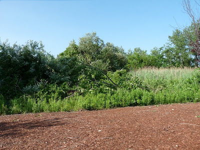
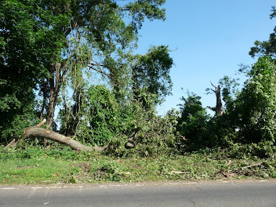
I took a tour of Stratford to survey damage this morning, out primarily to check on the CAS offices at Stratford Point. It turns out Stratford Point was just to the south of the most powerful winds. The Stratford Great Meadows Important Bird Area was directly in the path. It sustained a good deal of damage. It seems clear to me that Stratford took straight-line wind damage, hurricane-force in power, but not wind damage as a result of a tornado. The airport measured wind gusts of 75-80MPH, consistent with hurricane intensity (75+), and the damage backs this measurement. As you will see in the pictures that follow, the damage to trees, signs, and more all came from one direction - the west. Anything exposed to the west and positioned perpendicular to the wind direction was ravaged, and it was bent, broken, or pushed over to the east. For example, a line of trees going from west to east fared much better than a line going north to south.
Below are many pictures of possibly familiar areas altered by this historical storm. First, Great Meadows, the McKinney Refuge on Long Beach Blvd. and surrounding areas:
 More damage to that tree line.
 Shocking view - pulling into the parking area where they used to be numerous trees and a lot of shade. Warblers and other migrants hung over visitors all along this spot. You can almost see the dead tree in the back where we had an Olive-sided Flycatcher this year.
 Turning to the right from the previous photo, more of the parking area - most trees along the trail are in good shape. Note the light on the left where the large hole is and the trees from around the pond leaning over on the right.
 Tree damage around the pond - seems much more open, huh?
 More damage along the road, just west of the pond - again, notice in all of these pictures how the trees are downed from the west going to the east.
 This wooded area just after the pond, on the way to the warehouse pools, had multiple downed or snapped trees.
A couple shots from the Stratford Airport, where signs were ripped out or bent over. Planes were tossed around, too, though they took care of those already. Note the sign bent to the east.


Here is the devastation of Oak Bluff Avenue, the road that goes along Great Meadows on the east. These trees were exposed on the west side and took a brutal hit. Several families of migrants, from warblers to vireos to flycatchers, do use these trees in the spring in small numbers. Resident and breeding birds, from woodpeckers to orioles, do as well. Any that were downed or damaged are a significant loss.


Stratford Point had minor damage. It is a battle-tested location:
 There they are!
 Our new Purple Martin gourd tree! Not quite right.
 This would be why!
A few more shots of damage in area between Stratford Great Meadows IBA and Stratford Point:


Finally, a quick stop in the north end of Stratford at Boothe Park, the location of our hawk watch site, showed it took damage, too. One of the trees that we often lost sight of migrant hawks behind last fall got trimmed. I will write much more about this site as we near the fall raptor migration.
 The hill we use to count migrant hawks.
 The sometimes-in-the-way tree that had a first-year female Cape May Warbler last year and now lost a bit off the top and in the middle.
 The rose garden next to the hill with the tree in the background. The garden brings in many migrants during the hawk watch as well. Last fall it had an adult male Cape May Warbler along with a likely "Calaveras" Warbler, the old name of a western subspecies of Nashville Warbler.


Finally, a quick stop in the north end of Stratford at Boothe Park, the location of our hawk watch site, showed it took damage, too. One of the trees that we often lost sight of migrant hawks behind last fall got trimmed. I will write much more about this site as we near the fall raptor migration.
 The hill we use to count migrant hawks.
 The sometimes-in-the-way tree that had a first-year female Cape May Warbler last year and now lost a bit off the top and in the middle.
 The rose garden next to the hill with the tree in the background. The garden brings in many migrants during the hawk watch as well. Last fall it had an adult male Cape May Warbler along with a likely "Calaveras" Warbler, the old name of a western subspecies of Nashville Warbler.
The buildings and trees on Long Beach and Pleasure Beach look like they sustained some damage, mostly minor, though it is hard to measure the impact without being physically there because of their already dilapidated state. I viewed these areas from down in the parking lot of Long Beach and across Lewis Gut from behind the warehouses on Long Beach Blvd. Many Ospreys were perched in odd areas as most of the nests, probably 8-10 active, had been blown apart, off telephone poles, or collapsed with other structures. The movement of the storm and the way the winds came in would likely spare those areas from the worst damage, but it seems as if it took an unfortunate toll on the nesting Osprey population.
A team from the National Weather Service is surveying areas in Easton, Trumbull, Bridgeport, and Stratford today to determine if and where a tornado touched down. Although I have not seen it first hand, my guess would be that one briefly touched down in Bridegport. As previously mentioned, I believe all of Stratford's damage was from straight-line winds from a microburst, or macroburst. I will post more on this soon. We will definitely be getting a better look at everything once the repair and cleanup is complete, and will check to see if any of the habitat was greatly altered. I am already very concerned about the loss of or damage to many trees in the McKinney Refuge area, as it is so important for and popular to spring migrants.
2:24PM update: The NWS team confirmed a tornado touchdown in Bridgeport, as suspected, and reinforced what I hypothesized above.
...NATIONAL WEATHER SERVICE CONFIRMS TORNADO IN BRIDGEPORT
CONNECTICUT...

LOCATION...BRIDGEPORT. BRIEF TOUCHDOWN ON MAIN STREET...NICHOLS
STREET...AND CEDAR STREET...1 BLOCK NORTH OF INTERSTATE 95.
ESTIMATED TIME...230 PM
EF-SCALE RATING...EF1
ESTIMATED WIND SPEED...100 MPH
PATH WIDTH...100 YARDS
PATH LENGTH...0.15 MILES

THE DAMAGE REPORTED IN EASTON AND TRUMBULL WAS ASSOCIATED WITH
STRAIGHT LINE WIND DAMAGE AND IS NOT CONSISTENT WITH DAMAGE CREATED
BY A TORNADO.
Photos © Scott Kruitbosch


Thanks for documenting this Scott. Let's hope that the little "warbler oasis" near the Warehouse Pool can come back in comparatively little time. That location has been so terrific for warblers looking for a place to come down along the coast. It was a good American Woodcock spot as well, as you know.
ReplyDeleteThe Ospreys took a hard hit, as you pointed out. They seemed confused and stunned today.
Good work Scott, I see Lordship took a hit on the news, must have had your heart pumping!
ReplyDeleteLarry