If
you live in the greater Old Lyme area and are interested in the issues
we raised in our Connecticut State of the Birds 2012 report (“Where Is the Next Generation of Conservationists Coming From?”), you might want
to participate in our next community forum.
It’s Thursday, November 29, 7-9 p.m., at the First Congregational Church, 2 Ferry Road, Old Lyme.
Our partners are the Old Lyme Land Trust and the Lyme Land Conservation Trust.
The forum is free and we encourage the public to come and participate. Details are on our website.
Tom Andersen
Director of Communications and Community Outreach

Tuesday, November 27, 2012
Monday, November 5, 2012
Sandy/Frankenstorm aftermath #2 - Stratford Point severely damaged
It will come as no surprise to those of you familiar with Stratford
Point that it was severely damaged by coastal flooding, storm surge and
wave action during Frankenstorm. For those of you unfamiliar with the
site, Stratford Point is a peninsula in the Lordship section of
Stratford located near the mouth of the Housatonic River at 1207
Prospect Drive. The property is managed by Connecticut Audubon Society
and owned by Sporting Goods Properties, Inc., a subsidiary of E.I. du
Pont de Nemours and Company (DuPont). This property is the site of the
former Remington Gun Club, also referred to as the Lordship Gun Club,
which was operated as a trap and skeet shooting facility from 1926 to
1986.
The property consists of approximately 28 acres of upland and an additional 12 acres of shallow intertidal zone. The southeast‐facing section of Stratford Point’s shoreline (generally referred to as the ‘high-energy’ section of the shoreline) borders the Long Island Sound and is exposed to more intense wave action and wind shear than the north-facing section of the site (the ‘low‐energy’ beach), which is facing a relatively sheltered cove at the mouth of the river. The upland section of the site currently support coastal grassland habitat augmented with 96 native trees and shrubs planted this May by Sacred Heart University students and Connecticut Audubon Society through funding from the Connecticut Corporate Wetlands Restoration Partnership and the Connecticut Ornithological Association. For the most part, those additions came through relatively unscathed with the woody vegetation relatively small and low to the ground and tucked away in upland areas, though salt water may have something to say about that. See more detail on the restoration this spring in this post and read about the prescribed burn that preceded the planting at the site in February in this post.
Continuing backwards in time, a novel erosion control structure was constructed at Stratford Point in late 2011, as detailed in this post, in which then CAS Conservation Biologist Twan Leenders explained:
Please read the post in full for the complete background and further information on the erosion control structure - I assure you it is worth the time and exceptionally educational after what has happened! Amazingly, only 14 months after Irene we suffered another direct hit from a system with tropical origins as the hybrid Sandy/Frankenstorm obliterated the coastal dune system described. However, the geotextile tubes and basis of the erosion control system remained intact and largely in place, limited the overall damage and doing exactly as Twan described they were meant to. This was not always true in other parts of the property where the rock revetment wall was destroyed in some places with water eroding more of the upland and undermining the base. In this case, seeing may be better than reading, and below are extensive photos of the before and after of Stratford Point, the dune and erosion control system, and revetment wall.
These 'before' photos are from Sunday, October 28.


CAS Senior Director of Science and Conservation Milan Bull took these photos on Monday, October 29 during the morning as the storm moved in before retreating to safer ground.


I took these photos from dawn onward on Tuesday, October 30 as the storm moved away, still with very blustery conditions and extremely high water levels.


Here are some photos of the revetment wall and lighthouse with the first batch from October 30 and then some from subsequent days as well.


The water wrapped far into the cove and did some additional upland damage as well.


For one last stop in our journey backwards in time, see this post on Connecticut Audubon Society and Sacred Heart University receiving a grant from the Long Island Sound Futures Fund for much of the planning and surveying involved in this coastal restoration work. In the second photo, you can see Twan and Dr. Mark Beekey with Senator Richard Blumenthal, a dedicated supporter of the LISFF program and environmental protection in Connecticut. The Senator joined several state and federal officials including Governor Dannel Malloy and United States Secretary of Homeland Security Janet Napolitano in two Sikorsky Black Hawk helicopters on a tour of the devastated Connecticut coastline last Thursday morning, and I took this shot of one of the helicopters as it passed directly over the main building of Stratford Point.

I had no clue who was in either Black Hawk at the time as I was largely cut off from the world, but I knew it would be a list of impressive names and was glad to see they got a tremendous view of Stratford Point. Apart from me and my Shetland Sheepdog Zach in the grass below, there was also a great deal of destruction on the wondrous property for everyone on board the helicopters to take in. I wonder if the Senator recalled his involvement and mentioned the site and the project to Secretary Napolitano or Governor Malloy.
Our world certainly works in odd ways, doesn't it? The irony is stunningly stupendous to me. We certainly have our collective work cut out for us, but I cannot begin to imagine how much more damage may have been wrought had this incredible structure not been in place to protect much of the property. Sand can be replenished, grass replanted, and a fence reconstructed, but replacing the land lost would be much more difficult. I will post on the rare birds seen at Stratford Point the day after the storm tomorrow.
Scott Kruitbosch
Conservation Technician
Photos © Scott Kruitbosch and Milan Bull and not to be reproduced without explicit permission
The property consists of approximately 28 acres of upland and an additional 12 acres of shallow intertidal zone. The southeast‐facing section of Stratford Point’s shoreline (generally referred to as the ‘high-energy’ section of the shoreline) borders the Long Island Sound and is exposed to more intense wave action and wind shear than the north-facing section of the site (the ‘low‐energy’ beach), which is facing a relatively sheltered cove at the mouth of the river. The upland section of the site currently support coastal grassland habitat augmented with 96 native trees and shrubs planted this May by Sacred Heart University students and Connecticut Audubon Society through funding from the Connecticut Corporate Wetlands Restoration Partnership and the Connecticut Ornithological Association. For the most part, those additions came through relatively unscathed with the woody vegetation relatively small and low to the ground and tucked away in upland areas, though salt water may have something to say about that. See more detail on the restoration this spring in this post and read about the prescribed burn that preceded the planting at the site in February in this post.
Continuing backwards in time, a novel erosion control structure was constructed at Stratford Point in late 2011, as detailed in this post, in which then CAS Conservation Biologist Twan Leenders explained:
Hurricane/Tropical Storm Irene left Stratford Point's Long Island Sound-facing shore in shambles and during the month of August the site saw a lot of activity as this damage was repaired. Large trucks and several excavators moved mountains of large boulders into the storm-damaged revetment wall to stabilize and armor the 'high-energy' side of the site. The use of hard structures, such as rock or concrete walls, has traditionally been the method of choice to control erosion in tidal areas. However, in recent years this approach is being revisited and novel, 'soft' erosion control structures are being put to the test in many areas surrounding Connecticut. Connecticut Audubon Society, together with site-owner DuPont and specialized contractor 'All Habitat Services, LLC', is currently in the midst of constructing such a soft erosion control structure along the 'low-energy' north shore of Stratford Point - a novelty in Connecticut.
As their name suggests, these 'soft' structures are relatively flexible and can absorb some of a wave's energy as it crashes onto the structure, rather than deflect it like a hard surface would. The latter scenario often results in undermining of the structure and/or excessive erosion at its base, causing a sea wall to become compromised over time. In areas where wave impact is relatively minor and in areas of sensitive coastal habitat, a soft erosion control structure may be a better fit. The northern cove of Stratford Point fits both descriptions since its orientation protects it from most direct wave impacts while the coastal habitat found on-site is among the most threatened in the state. Once completed, the newly constructed erosion control feature will be contoured, covered with a thick layer of sand and planted with 38,000 dune grass plugs to form an artificial coastal dune system extending the length of the north shore.
Please read the post in full for the complete background and further information on the erosion control structure - I assure you it is worth the time and exceptionally educational after what has happened! Amazingly, only 14 months after Irene we suffered another direct hit from a system with tropical origins as the hybrid Sandy/Frankenstorm obliterated the coastal dune system described. However, the geotextile tubes and basis of the erosion control system remained intact and largely in place, limited the overall damage and doing exactly as Twan described they were meant to. This was not always true in other parts of the property where the rock revetment wall was destroyed in some places with water eroding more of the upland and undermining the base. In this case, seeing may be better than reading, and below are extensive photos of the before and after of Stratford Point, the dune and erosion control system, and revetment wall.
These 'before' photos are from Sunday, October 28.

Looking southwest towards the lighthouse

Looking northeast towards the mouth of the Housatonic

The rock revetment wall was repaired only last year post-Irene

Eastern end of the constructed dune/erosion control structure

Looking west

Stratford Point's cove

A closer look

Water was beginning to creep to the base, not far from where it normally peaks

A beautiful piece of work
CAS Senior Director of Science and Conservation Milan Bull took these photos on Monday, October 29 during the morning as the storm moved in before retreating to safer ground.

Far higher than we'd ever seen

Waves would only increase

Pummeling the fence

Here it comes but...

...can you imagine what the high tide with the highest storm surge ever recorded in Bridgeport later that night looked like?
I took these photos from dawn onward on Tuesday, October 30 as the storm moved away, still with very blustery conditions and extremely high water levels.

Driving up just past dawn as I was able to navigate my way to the coast - storm surge pool and a wrack line on Prospect Drive, ut oh

Greg Hanisek, Frank Mantlik and I scoped things out all morning - damage on the buildings amounted to torn off siding and shingles, though this year-old roof held up well

The beginning of what was the dune on the east side

The dune was annihilated

Looking west at the length of it

See all the geotextile tubes?

The tubes were uncovered nearly completely

However, they are mostly in place and intact

More is covered by the more sheltered part of the cove

See how much more sand was deposited here as well

I did not expect to see these tubes ever again

Some erosion limited to the edge of what was the dune

Just amazing

A good sense of where the dune and land were

The damage spanned the length of the system relatively evenly

How poetic
Here are some photos of the revetment wall and lighthouse with the first batch from October 30 and then some from subsequent days as well.

Many rocks tumbled down the wall

And many more were ripped from it along with the base and fabric beneath

There were small but sizable rocks thrown tens of feet or more upland

Note how much elevation was lost, especially here and on the low-energy side

The lighthouse was fine but surrounding buildings also had CAT 1 damage

This
is actually more storm surge residual flooding - we had less than 0.5
inch of rain during the event! Imagine how much water washed over the
walls

Check out the size of these boulders heaved so very far

Totally crazy

Soon this perimeter path will be near sea level
The water wrapped far into the cove and did some additional upland damage as well.

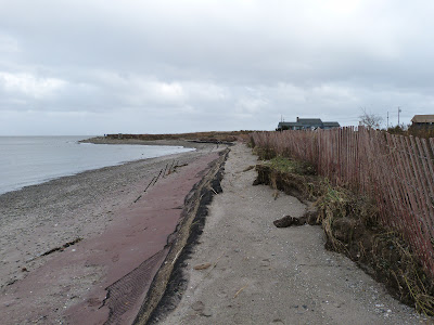
This new fence took a beating

Between the water and debris it was tossed around like a toy

This is some damage to the dune with sand covering much of it, but it may end up being prime habitat for some species - could it be time for Piping Plovers or Least Terns near Stratford Point?
For one last stop in our journey backwards in time, see this post on Connecticut Audubon Society and Sacred Heart University receiving a grant from the Long Island Sound Futures Fund for much of the planning and surveying involved in this coastal restoration work. In the second photo, you can see Twan and Dr. Mark Beekey with Senator Richard Blumenthal, a dedicated supporter of the LISFF program and environmental protection in Connecticut. The Senator joined several state and federal officials including Governor Dannel Malloy and United States Secretary of Homeland Security Janet Napolitano in two Sikorsky Black Hawk helicopters on a tour of the devastated Connecticut coastline last Thursday morning, and I took this shot of one of the helicopters as it passed directly over the main building of Stratford Point.

I had no clue who was in either Black Hawk at the time as I was largely cut off from the world, but I knew it would be a list of impressive names and was glad to see they got a tremendous view of Stratford Point. Apart from me and my Shetland Sheepdog Zach in the grass below, there was also a great deal of destruction on the wondrous property for everyone on board the helicopters to take in. I wonder if the Senator recalled his involvement and mentioned the site and the project to Secretary Napolitano or Governor Malloy.
Our world certainly works in odd ways, doesn't it? The irony is stunningly stupendous to me. We certainly have our collective work cut out for us, but I cannot begin to imagine how much more damage may have been wrought had this incredible structure not been in place to protect much of the property. Sand can be replenished, grass replanted, and a fence reconstructed, but replacing the land lost would be much more difficult. I will post on the rare birds seen at Stratford Point the day after the storm tomorrow.
Scott Kruitbosch
Conservation Technician
Photos © Scott Kruitbosch and Milan Bull and not to be reproduced without explicit permission
Sunday, November 4, 2012
Sandy/Frankenstorm aftermath #1 - Brown Pelican at Stratford Point
Frankenstorm turned out to be exactly what we thought it would be in nearly every way possible, from storm track to wind intensity to rainfall (or lack of) and, most notably and unfortunately, storm surge. I am now "back", having power restored at home and all networks up at the office. Suffice it to say there is an enormous amount of everything for me to catch up with, so I will keep the heavier posts for later in the coming week. I discussed the storm in this post a week ago, and in the coming days I will analyze it further in terms of impact, actualized weather, changes in our state, and what we need to learn from this system. I will also share some of the incredible bird sightings as Frankenstorm littered Connecticut and neighboring states and waters with a bounty of wondrous species. I am still calling the system "Frankenstorm" because it was truly an unprecedented hybrid that crushed our area, one that we will never forget - more on that in an upcoming post.
On Friday afternoon, I had a Brown Pelican fly over me at Stratford Point so close that my fully zoomed-in camera could not focus on it. I eventually snapped off some shots as it spiraled in the sky over the lighthouse before heading west.

.JPG)
I have now enjoyed the rarer pelican at Stratford Point in each of the last three years! One flew by randomly while a group of us awaited the White-tailed Kite's nightly feeding session in August 2010, and Irene put one in the mouth of the Housatonic in 2011. This is the fourth year in a row I have had a pelican species at Stratford Point as in December 2009 several observers got fast but distant views of a group eight American White Pelicans we tracked down the Connecticut coast as they headed west.
The fact these rarities are showing up with regularity portrays our very turbulent start to the century. While you absolutely cannot pin down one event and blame it all on climate change - it is weather and nothing more - it is almost like we have a sizable trend of volatile, unpredictable, and record-setting weather in Connecticut, isn't it? There is no doubt the world is changing far too rapidly, with warmer temperatures and sea-level rise exacerbating our problems. While history has shown the Earth has had its ups and downs, the key is that they were not caused by human pollution, and as such they did not happen at this frenetic pace. Unimaginable consequences like this storm will keep happening more frequently. I will be posting something on the storm and its birds every day for the next week.
Scott Kruitbosch
Conservation Technician
Photos © Scott Kruitbosch and not to be reproduced without explicit permission
Subscribe to:
Posts (Atom)