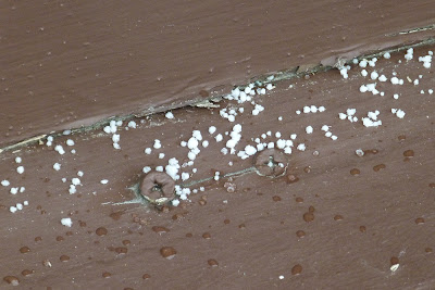
Last week in this post I asked if anyone could tell me what the type of precipitation in the photo was. Here is that photo once again.
I can give you a hint - it is not rain and it is not snow. Those were mostly obvious, though, especially when you consider the scale of the photo and that this is indeed a close-up shot of small white things that are not snowflakes. Most of you are probably going to say hey, wait a minute, if it not snow, and not rain, then it has to be in between - ice. That must mean it is sleet! Nope, not quite. Hail? Not that either, but close. Aren't those the same thing? Actually, no. It is, as the person who commented on that post correctly asserted, graupel! What the heck is that you say? Allow me to explain...
Graupel is a form of precipitation that occurs when snowflakes, while falling from thousands of feet aloft down to us at the surface, accumulate supercooled water droplets on them. These droplets instantly freeze on the snowflake, and while the droplets may cover it they do not compress it entirely. You are essentially left with an opaque round or conical object. It features a snowflake core having this very thin glaze of the supercooled and then frozen water on top of the snow. Since it is not compressed fully and is largely the remains of a snowflake compacted into a ball, graupel bounces really well off of hard surfaces, and it was doing so off the roof, sidewalk, and porch at Stratford Point when I took the photos. Bearing in mind that it is not a ball of ice, it did not make much noise at all, unlike sleet or hail which have greater concentrations of more dense ice.
If you touched the graupel in the photo you would find that you would be able to easily smash any of the little balls. They fall apart like lumps of flour in your hands unlike sleet which is entirely ice. Apart from rain and snow our other major form of winter precipitation is sleet. It is formed by passing through a warmer then freezing layer of air that is surrounded above and below by freezing air. This warm layer is usually about one to two miles above the surface, and it is a common occurrence in many types of winter storm setups. Graupel is a rare form of precipitation in that you have to have snow encountering a layer of those supercooled ice crystals while they fall, and I was happy to see it falling on me.
Scott Kruitbosch
Conservation Technician
Photo by Scott Kruitbosch © Connecticut Audubon Society and not to be reproduced without explicit CAS permission


No comments:
Post a Comment